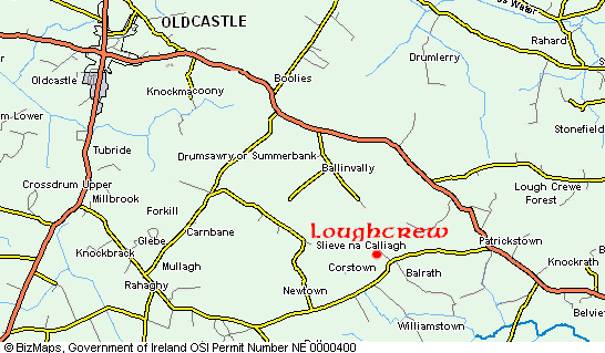
Map and Directions to Loughcrew Cairns
The Loughcrew Cairns are located 80 km (50 miles) northwest of Dublin, close to the town of Oldcastle. From Dublin, take the M3 towards Kells, then take the Oldcastle road to Loughcrew.
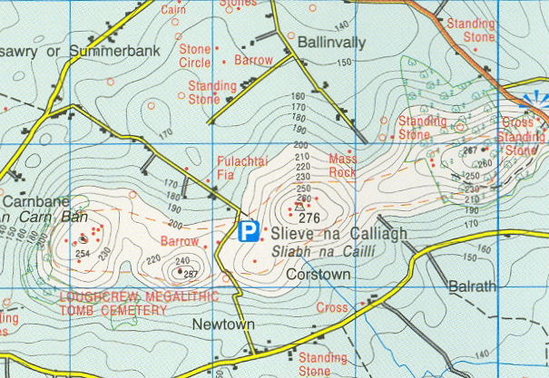
Ordnance Survey map 42
Car Park N 53.744083° (N 53°44.645) W 7.118783° (W 007°07.127)
Cairn T N 53.744833° (N 53°44.690) W 7.112217° (W 007°06.733)
Carnbane East, Loughcrew
Carnbane East is the principal hill of the Loughcrew passage tomb complex and contains one of the most important concentrations of Neolithic monuments in Ireland. Rising to 275 metres (904 feet) above sea level, it is the highest point in County Meath and commands extensive views across much of the Irish midlands. The hill forms part of the wider Sliabh na Calliagh cemetery, a remarkable collection of passage tombs built more than 5,000 years ago.
At the summit stands Cairn T, the best-known monument at Loughcrew and the focal point of a cluster of smaller tombs. The cairn measures approximately 35 metres in diameter and contains a cruciform chamber reached by a passage almost 9 metres long. Excavations carried out by Eugene Conwell in the 1860s revealed cremated human remains, charcoal and other evidence of burial activity, confirming the site's importance as both a funerary and ceremonial centre.
Carnbane East is particularly celebrated for its rich collection of megalithic art. Many of the stones within Cairn T and the surrounding monuments are decorated with spirals, circles, chevrons, lozenges and other geometric motifs. These carvings rank among the finest examples of Neolithic art in Europe. Although their precise meanings remain unknown, archaeologists believe they played an important role in the rituals and beliefs associated with the monuments.
One of the most remarkable features of Cairn T is its solar alignment. Around the spring and autumn equinox period, the rising sun illuminates the decorated backstone deep within the chamber. The phenomenon was first recorded by Martin Brennan in 1980 and attracts visitors who gather before dawn to witness the sunlight slowly reveal the intricate carvings inside the tomb.
Carnbane East contains several other important monuments, including Cairns S, U and V, as well as a number of smaller satellite tombs surrounding Cairn T. Together these structures form a carefully planned ceremonial landscape that was used by generations of Neolithic communities. The concentration of monuments on the hill suggests that Carnbane East was a place of exceptional significance within prehistoric Ireland.
The modern understanding of Loughcrew owes much to Eugene Alfred Conwell, who undertook the first detailed survey and excavation of the cairns after discovering them in 1863. His system of lettering the monuments, including Cairn T, remains in use today. Conwell also commissioned detailed drawings of the megalithic art, creating an invaluable record of carvings that have weathered over time.
Today Carnbane East remains one of Ireland's most impressive prehistoric landscapes. Its combination of monumental architecture, exceptional megalithic art, archaeological importance and panoramic views makes it one of the country's most significant Neolithic sites, comparable in importance to Newgrange, Knowth and Dowth in the Boyne Valley.
 Ordnance Survey of Ireland © Government of Ireland / Rialtas na hÉireann
Loughcrew Gardens
 Loughcrew Gardens and coffee shop are located about 3 KM (2 miles) from Loughcrew Cairns.
The Naper family have been creating Loughcrew Gardens since 1660. The result is a garden comprising water, trees, vistas and archaeology rather than flowerbeds. The surviving 17th century features include a yew walk, foundations of a longhouse and a walled garden from which a canal and a parterre have been relocated in replica.
In the 19th century these earlier elements were enveloped in a development of parkland, water gardens, specimen trees, follies, rockeries, wood walks and vistas. The central area of approximately six acres now includes a lime avenue, lawns, terraces and a herbaceous border.