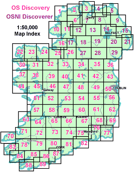
Discovery Maps
Detailed Maps of Ireland in 40km x 30km Sections
Discovery Series Ordnance Survey maps provide detailed coverage of Ireland in clearly defined 40km by 30km sheets. They are particularly useful for locating heritage sites such as Megalithic Tombs, Standing Stones, Castles, Holy Wells and Churches, many of which are not signposted on the ground.
The scale of the maps is 1:50000 (2cm to 1km), offering an excellent balance between clarity and coverage. Field boundaries, minor roads, tracks, rivers, contours and townlands are all clearly shown, allowing users to understand both individual sites and their wider landscape setting.
The grid system makes it easy to cross reference guidebooks, archaeological reports and GPS coordinates. For research, fieldwork or general landscape study, the Discovery Series remains one of the most practical and reliable map resources available for Ireland.
Available for sale from Ordnance Survey Ireland, Amazon.com and Amazon.co.uk.
- Map 1 – Donegal (Northwest)
- Map 2 – Donegal (North Central)
- Map 3 – Donegal (Northeast), Derry
- Map 4 – Coleraine, Northern Ireland
- Map 5 – Ballycastle, Northern Ireland
- Map 6 – Donegal (Central), Tyrone
- Map 7 – Derry, Northern Ireland
- Map 8 – Ballymoney, Northern Ireland
- Map 9 – Ballymena, Larne, Northern Ireland
- Map 10 – Donegal (Southwest)
- Map 11 – Donegal (South)
- Map 12 – Strabane, Northern Ireland
- Map 13 – The Sperrins, Northern Ireland
- Map 14 – Lough Neagh, Northern Ireland
- Map 15 – Belfast, Northern Ireland
- Map 16 – Donegal, Fermanagh, Leitrim, Sligo
- Map 17 – Lower Lough Erne, Northern Ireland
- Map 18 – Enniskillen, Northern Ireland
- Map 19 – Armagh, Northern Ireland
- Map 20 – Craigavon, Northern Ireland
- Map 21 – Strangford Lough, Northern Ireland
- Map 22 – Mayo (Northwest)
- Map 23 – Mayo (North Central)
- Map 24 – Mayo (Northeast), Sligo
- Map 25 – Sligo (East), Leitrim, Roscommon
- Map 26 – Cavan, Fermanagh, Leitrim, Roscommon, Sligo
- Map 27 – Upper Lough Erne, Northern Ireland
- Map 27A – Cavan, Fermanagh, Leitrim, Monaghan
- Map 28 – Monaghan, Armagh (South)
- Map 28A – Cavan, Fermanagh, Monaghan, Tyrone
- Map 28B – Armagh, Cavan, Monaghan, Tyrone
- Map 29 – Newry & Mourne, Northern Ireland
- Map 30 – Mayo (West Central)
- Map 31 – Mayo (Central)
- Map 32 – Mayo, Roscommon, Sligo
- Map 33 – Leitrim, Longford, Roscommon, Sligo
- Map 34 – Cavan, Leitrim, Longford, Meath, Monaghan
- Map 35 – Cavan, Louth, Meath, Monaghan
- Map 36 – Louth (Dundalk, Carlingford Lough)
- Map 37 – Mayo (Southwest), Galway (Northwest)
- Map 38 – Galway (North Central), Mayo (South Central)
- Map 39 – Galway (Northeast), Mayo, Roscommon
- Map 40 – Galway, Longford, Roscommon, Westmeath
- Map 41 – Longford, Meath, Westmeath
- Map 42 – Meath, Westmeath – including Loughcrew
- Map 43 – Dublin, Louth, Meath – including Newgrange
- Map 44 – Galway (Southwest)
- Map 45 – Galway (South Central)
- Map 46 – Galway (Southeast)
- Map 47 – Galway, Offaly, Roscommon, Westmeath
- Map 48 – Offaly, Westmeath
- Map 49 – Kildare, Meath, Offaly, Westmeath
- Map 50 – Dublin, Kildare, Meath, Wicklow
- Map 51 – Clare (Northwest), Galway
- Map 51A – Aran Islands
- Map 52 – Clare, Galway
- Map 53 – Clare, Galway, Offaly, Tipperary
- Map 54 – Laois, Offaly, Tipperary
- Map 55 – Kildare, Laois, Offaly, Wicklow
- Map 56 – Wicklow, Dublin, Kildare
- Map 57 – Clare (Southwest)
- Map 58 – Clare, Limerick, Tipperary
- Map 59 – Clare, Offaly, Tipperary
- Map 60 – Kilkenny, Laois, Tipperary
- Map 61 – Carlow, Kildare, Kilkenny, Laois, Wicklow
- Map 62 – Carlow, Wexford, Wicklow
- Map 63 – Clare, Kerry (Listowel area)
- Map 64 – Clare, Kerry, Limerick
- Map 65 – Clare, Limerick, Tipperary
- Map 66 – Tipperary, Limerick
- Map 67 – Kilkenny, Tipperary
- Map 68 – Carlow, Kilkenny, Wexford
- Map 69 – Wexford
- Map 70 – Kerry (Dingle area)
- Map 71 – Kerry (Tralee area)
- Map 72 – Kerry, Cork, Limerick
- Map 73 – Cork, Limerick
- Map 74 – Cork, Limerick, Tipperary, Waterford
- Map 75 – Kilkenny, Tipperary, Waterford (North)
- Map 76 – Carlow, Kilkenny, Waterford, Wexford
- Map 77 – Wexford
- Map 78 – Kerry (Killorglin, Killarney) – including Killarney National Park
- Map 79 – Cork, Kerry
- Map 80 – Cork
- Map 81 – Cork, Waterford
- Map 82 – Waterford
- Map 83 – Kerry (Caherciveen area)
- Map 84 – Cork (Castletown Bearhaven), Kerry (Waterville, Sneem)
- Map 85 – Cork (Bantry area), Kerry
- Map 86 – Cork (Clonakilty)
- Map 87 – Cork
- Map 88 – Cork (Southwest)
- Map 89 – Cork (Skibbereen area)