Tara: An Archaeological Survey
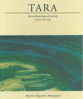 Tara - An Archaeological Survey by Conor Newman.
Discovery Programme Reports 5 (Monograph 2).
The 5th publication in the Discovery Programme series and the first of the full archaeological reports. Tara - An Archaeological Survey gives the first complete survey of what is regarded as the most important archaeological site in Ireland covering a combination of topographical, geophysical, aerial, geochemical and paper surveys.
Purchase at Amazon.com or Amazon.co.uk
Extract from Tara: An Archaeological Survey
The Hill of Tara lies about midway between the towns of Dunshaughlin and Navan in the gently rolling countryside of south central Meath. The monuments comprising the core of the Tara complex are scattered along a low ridge about 2km long, orientated roughly north—south, a little to the west of the main Dublin-Navan road. Unimposing from the east, which is the usual modern approach, the ground rises steadily to about 155m above sea-level before dropping away quite steeply to the west, presenting an impressive vista over the central plain of Ireland.This aspect is implicit in one of the two etymologies of its Irish name, Teamhair, provided by the ninth-century text Sanas Chormaic, i.e. a height from which there is a fine view. An alternative, and possibly more accurate, etymology emphasises the liminal nature of Tara, suggesting that the name has something to do with twilight or darkness, perhaps a sacred space or the gates to the Otherworld. It is likely, nevertheless, that the sense of elevation at Tara, which is conferred by the surrounding panorama rather than by its actual height above sea-level, was a key factor in the choice of this place for ceremonial activity.
From Tara the southern horizon is dominated by the Dublin and Wicklow mountains, and to the west lie the broad plains of Kildare, Laois, Offaly and Westmeath. The north-western horizon is defined by Slieve na Calliagh, near Oldcastle, Co. Meath, on whose summits are visible the larger mounds of the Loughcrew passage tomb cemetery. In the middle distance, a little further north, is the monastery town of Kells, and behind it the Hill of Lloyd with its eighteenth-century lighthouse tower, once the site of a multivallate hillfort. Hidden from view below Kells is Teltown, where Oenach Tailten was held periodically; presided over by the king of Tara, it was the most famous of the Lughnasa assemblies. To the north-north-west are the Loughanlea Mountains, overlooking Kingscourt and Baileborough, Co. Cavan. Slieve Gullion, in south Armagh, defines the northern horizon, and it too is topped by a large passage tomb cairn.
To the east are the Mourne Mountains, forming a spectacular backdrop to the Cooley Mountains in County Louth, the setting for the tragic climax of the Táin Bó Cuailnge ('Cattle Raid of Cooley'). In the middle distance south of these is the Boyne Valley, the bright white quartz facade of Newgrange passage tomb, legendary burial-place of the pagan kings of Tara, just visible to the naked eye some 16km away. Due east, and considerably closer, is the Hill of Skreen, with the ruins of a fifteenth-century Augustinian priory. To the south among the hills around Naul, Co. Meath, are the passage tomb cemetery at Fourknocks and the hillfort and tumulus cemetery of Knockbrack.
The remains of over thirty monuments are visible on the Hill of Tara today. Almost all of them are prehistoric. Some, such as the Forrad, Tech Cormaic, Tech Midchúarta and Rath Maeve, are imposing earthworks. Others appear only as barely discernible circles and mounds in the grass, or as appendages incorporated into later monuments. The long and relatively flat summit of the hill is dominated by the largest enclosure, Ráith na Ríg, which is defined by a bank and internal fosse, a feature it shares with the large enclosures at Navan and Knockaulin.
The majority of monuments, however, are barrows of one type or another, suggesting that Tara was a cemetery for at least part of its history The majority of the monuments in the surrounding countryside are also ritual in character, though this is probably due to the generally better survival rate of monumental ritual earthworks and the contrasting difficulty of identifying prehistoric settlement on the basis of survey alone. The Hill of Tara merges into this landscape, both literally and metaphorically, in so far as the absence of a clear dividing line between the Hill of Tara and its immediate hinterland is a metaphor for the mergence of ritual into everyday life in prehistoric Ireland.
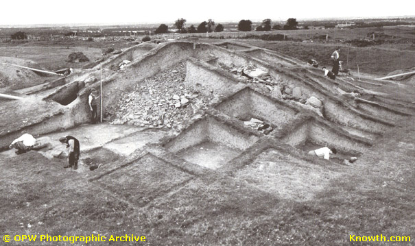
Mound of the Hostages (Tara) under excavation in 1955
Boyne Valley Private Day Tour
Home
| Newgrange
| Knowth
| Dowth
| Hill of Tara
| Fourknocks
| Loughcrew
| More Places
| Labyrinths
| Local Info
| Art Works
| Articles
| Images
| Books
| Links
| Boyne Valley Tours
| Contact