Magic of Fourknocks - A Place of endless majesty and beauty
By Brendan Matthews, Community Historian - Printed in the Drogheda Independent, February 2024
As a young lad growing up within the parish of Stamullen back in the later 1960s and 70s I developed a great love of Irish History and Prehistory.
Playing amongst the ruinous burial tombs along the coast at Gormanston to the awe-inspiring Tomb at Fourknocks and the magnificent 40 metre Souterrain and chamber at Herbertstown, amongst other sites.
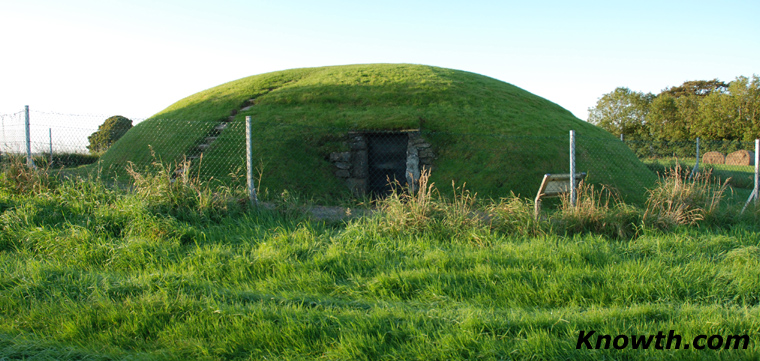
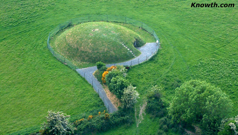 Fourknocks Megalithic Passage Tomb
It was a fantastic place to ramble and explore on Saturday mornings, summer evenings and holiday times. The Parish of Stamullen was made up of 17 townlands all of which were contained within five-thousand acres of land and at the extreme western end of the parish was situated the smallest of these 17 townlands which was that of the Fourknocks containing just 86 acres.
Families who have resided in the immediate area of the Fourknocks had always referred to the place-name as "The Knocks" as referring to the original Four Burial Mounds which were grouped in close proximity on the summit of the north facing hill overlooking the archaeologically rich valley of Micknanstown below.
In the Ordnance Survey Field Name Books of the mid 1830s, in referencing the name of Fourknocks, the wonderful Irish Language Scholar, John O'Donovan, records two names "Fuar Cnoc" meaning 'Cold Hills' and also "Na Ceathair Cnoc" meaning "Four Hills". John O'Donovan then goes on to record in the same notes that "Na Ceathair Cnoc (Four Hills) is not the correct name" however, he does not elaborate nor provide no further evidence as to why he adopted the name of "Fuar Cnoc" i.e the "Cold Hills".
The tremendous detailed work that John O'Donovan carried out during the 19th century is extraordinary. He was recruited to the Topographical department of the very first Ordnance Survey of Ireland where he carried out detailed work from 1830 until 1842.
However, just like anyone else, he was only human and like us all, was subject to mistakes and misinterpretations.
As an example, there are a number of place-names dotted across the greater East Meath & Fingal district that I and many other historians have looked at and which were either incorrectly identified by O'Donovan and his Surveyors and/or not identified at all in some cases during the 1830s.
The east-west saddle-back gravel ridge on which the Fourknocks Neolithic Cemetery is situated contains a number of other Neolithic and Early Bronze Age sites in the immediate vicinity including Barrows, Enclosures, Ring Ditches, Pit Burials, Cist Graves and Fulacht Fiadhs.
The adjacent area to the east of the Fourknocks is documented & recorded as Tír Rí, meaning 'Land of the King' or 'King's Country'. Local Mythology refers to the area of Tír Rí as being that of the "Summer Residence of the High Kings of Tara" and that their Pleasure Grounds of Sport & Recreation was situated on the Hill of Crocafotha, which would be today's Hill of Bellewstown.
Both the Hill of Fourknocks and the Hill of Bellewstown are situated over 500 feet above sea-level and are separated by the valley of Micknanstown and Heathstown, known locally as the "Haytown".
Local lore also refers to this specific area within the townland of Fourknocks as just simply "The Knocks", meaning the hills or 4 original burial mounds, i.e. the word knock very often referring to artificial mounds on the landscape.
The very first time that the name "The Four Knocks" is documented and recorded on a Map was prepared for the Grand Jury of County Meath by the Cartographer William Larkin which was first produced in the year 1812, nearly a quarter of a century before John O'Donovan and his team of Surveyors undertook the task for the initial Ordnance Survey six inch to one mile Maps of the mid to late 1830s with their accompanying Administrative Ordnance Survey Field Name Books.
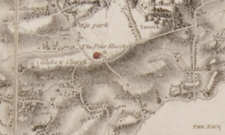 William Larkin 1812 Grand Jury map showing 'The Four Knocks'
Larkin was commissioned to prepare the work for the map at a time when the landscape across the county and indeed the country as a whole was undergoing major changes.
The Land Enclosure Act was well underway and farming land and fields, etc. were now being enclosed in their own right by hedgerows on orders of the English Government. There was a newly developed road network in place with larger and faster carriages and it was also the initial stages of the Industrial period.
This was the grandeur of all that was the Georgian Period of the later 18th and early 19th century and when the "Big Houses" were being constructed by the Ascendancy of the day.
Fourknocks did Not, at this period (1812), exist as a townland but was part of the much larger townland of Herbertstown, known locally as "Harbourstown".
The entire townland of Herbertstown contained more than 595 acres of land; the majority of which was under the control of the Caddell family of Herbertstown House. The Caddell family were that of an Anglo Norman family who had resided on the Meath bank of the Delvin River at Naul since the 13th century and they also contained land and other properties in the Herbertstown and surrounding area since the early 15th century. During the 1760's the Caddell family constructed a new Georgian Mansion within the townland of Herbertstown and just below the hill of Tír Rí and all its archaeological sites & monuments on the ridge of the hill.
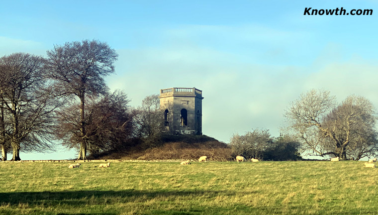 Herbertstown Folly or Gazebo erected on top of a pre-existing earthen mound
The Caddell family also erected a large cut-stone and decorative Folly or Gazebo on top of a pre-existing substantial earthen mound less than one kilometre to the east of the Fourknocks Cemetery Mounds which, due to the position of this Mound, very possibly also contains a Passage Tomb beneath.
In fact, in recent years Archaeological Surveys have revealed this whole area along the 500 foot contour of Tír-Rí as that of an Archaeological Landscape.
It was during this period of the later 18th and into the first decade of the 19th century when major changes across the large Demesne of Herbertstown House and adjacent lands took place; hence the Grand Jury map of Co. Meath by William Larkin was produced to reflect these changes across the landscape.
Larkin's Map of 1812 depicts local Place-names across this newly developed Demesne and adjacent land including the names of "White Park", the "Folly Field" and the "Fourknocks" and this is the first recorded entry of that particular name of "The Fourknocks" either in the Gaelic or Anglicised form. The Grand Jury Map of 1812 also clearly depicts the images of the Four (4) round mounds that stood here in close proximity at this period.
By 1835/36, when John O'Donovan and his Surveyors were undertaking their task of collecting and recording the townlands and other names of interest within townlands it is of some note that the Fourknocks only comes into existence at this time as a Townland and is recorded as the smallest townland within the parish of Stamullen for the very first time.
It is of further note that the smallest Land Unit on the Irish landscape is that of the townland which was only first determined and established within the Irish Administrative System during the later 1820's and 30's; however many of the townlands were in existence prior to this period.
The first recorded listing of the Townlands contained within the parish of Stamullen occurs in the early 15th century and contains 17 townlands of which Fourknocks is not one.
Contained within the 16th century Calendar Documents of Ireland in relation to Queen Elizabeth 1st at the year 1567 there are 19 townlands recorded within the Parish of Stamullen: namely Ballestran, Balloy, Baltray, Canthenston, Clinstown, Damselstown, Giblockstown, Gormanston, Greenanstown, Herbertstown, Hodgeston, Kilbreckstown, Knockbeg, Lacystown, Saddlestown, Stamullen, Stedalt, Tullog and Whiteleas.
Now, when we move on to the first publication of the Ordnance Survey map of 1835/36 and the accompanying Field Name Books prepared by John O'Donovan and his Surveyors, there are only 17 townlands; all of the above named townlands with the exception of Baltray which was that section of land east of Gormanston in the area of the coast and Canthenston, which was a small area adjacent to that of Stamullen Village and which had, at some earlier time, been adopted into the townland of Stamullen.
This leaves 17 townlands, however, the name of the former townland above as recorded in the year 1567 as 'Knockbeg' is also gone by 1835/36 and this townland name has been replaced by that of 'The Fourknocks', although it is in a completely different location and it is here when more confusion may have arisen in the past and needs further explanation.
Father Paul Walsh, Church Curate at Stamullen from the late 1920's to 1932, was an eminent Irish scholar and renowned Historian. It was Father Walsh who made the entry in his Parish Annals of Stamullen, titled "Leaves of History" and published in 1930, that the townland of Knockbeg which first appeared in 1567 in an Elizabethan Document was that of Fourknocks.
However, with the greatest of respect to the former Parish Curate, Father Paul Walsh was incorrect in this identification.
A Researched study, carried out by myself regarding the Civil Survey of County Meath, Parish of Stamullen and which was undertaken by Cromwellian Forces in the year 1654 clearly identifies where exactly the place-name of Knockbeg was located.
This very detailed 17th century Survey, along with the contemporary and detailed William Petty's Down Survey Map of 1659, clearly and distinctly shows that Knockbeg was situated overlooking the north bank of the Delvin River between the townland of Tullog and that of Hodgestown and close to the village of Naul a distance of over two kilometres to the south-east of the place we know today as Fourknocks.
The names of both Tullog and Knockbeg are also Anglicised names of the Gaelic word Cnoc meaning hill and many such names often refer to that of an 'artificial' hill or earthen mound; there are a number of such archaeological earthen mounds overlooking the Delvin River in both the townland of Tullog and the former townland of Knockbeg.
At some time after the mid 17th century the former townland of Knockbeg was incorporated into the adjacent townlands of Tullog to the east and that of Hodgestown to the west.
It is of particular interest also that; of the 17 townlands recorded by O'Donovan across the parish of Stamullen in the mid 1830s, 16 of them contained documented evidence, as showing that they had existed on the landscape since at least the early 16th century.
 Entrance to
Fourknocks
Passage Tomb
Entrance to
Fourknocks
Passage Tomb
That just leaves one townland, that of Fourknocks containing some 86 acres of land that had been initially incorporated as an Administrative unit division of land, i.e. a Townland in its own right and which was only created in the mid 1830s under this particular topographical Survey.
Hence, when John O'Donovan records the name of Fourknocks within the Ordnance Survey Field Name Books, he has nothing to say about it, no origins of the name itself and no earlier date prior to 1812 of the name having existed before this and so he list it as a new townland and, incorrectly, decides to 'highlight' the Anglicised version of the name into Gaelic as his summary of the translation of that name.
Griffiths Valuation of Rateable Property in Ireland carried out between 1848 and 1854 records that there are 23 houses within this newly defined townland of Fourknocks and in the later 19th century, it was described and recorded as the Village of Fourknocks.
When you look at the Grand Jury Map of 1812 and the very first recording of that name, it is documented on the map as "The Fourknocks"; it is recorded in what is known as a half-translation of the numerical 'Four' as pertaining to that of the four (4), earthen mounds that stood proud on the summit of the hill and the Anglicised name of Knocks in relation to the same 4 mounds, it becomes very clear as to what William Larkin is indicating on the map and he goes on to clearly depict the symbols of the four mounds on the map.
It is very easy for many to accept John O'Donovan's original claim that the name refers to that of Fuar Cnoc, (Cold Hill), especially if you happen to visit this saddle-backed windswept terrain located, as it is, some 500 feet above sea-level on a cold winter's day!
This Grand Jury map by William Larkin in 1812 clearly and without any denial identifies this small group of earthen mounds on the summit of the hill as "The Four Knocks", in the Anglicised term, not the Gaelic and, most importantly, Larkin identifies the Mounds/knocks in the plural as there being more than just one?
There is no tradition, nor account, oral or otherwise within the immediate area of Four Knocks that it was ever called or named An Fuar Cnoc in the Gaelic nor from the Anglicised name of The Cold Hills, but that the name in English, The Four Knocks, as Larkin had found it in 1812 following on from the huge landscape changes of the later 18th and early 19th century is the correct one which he then recorded in detail a depiction of the four prehistoric burials that stood here at this period.
Today, all that can be seen standing proud on the summit of the hill is the beautifully restored Neolithic Passage Tomb; the remaining three mounds may only be seen as humps & bumps in the adjoining field.
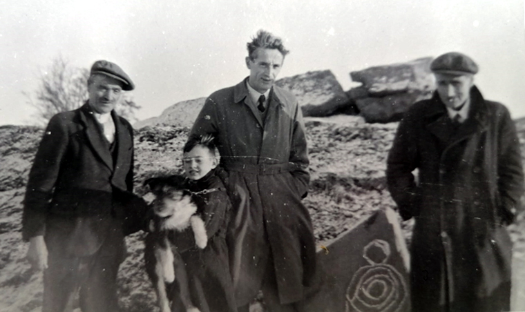 P.J. Hartnett who
excavated Fourknocks
(centre of photo)
P.J. Hartnett who
excavated Fourknocks
(centre of photo)
These archaeological sites were also excavated by the late P.J. Hartnett in the early to mid 1950s and found to contain archaeological material evidence dating to the later Neolithic and Early Bronze Age period including Pit and Urn Burials and Cist Grave, while a few years back, a large Circular Embanked Enclosure measuring some 90 metres in diameter was also discovered just to the north of the entrance to the Neolithic Crematorium Passage. Taking a look at the place-name of The Four Knocks from a new perspective of the map of 1812 and the recording of the Ordnance Survey Field Name Books of the mid 1830s is, in my opinion, more than suggestive that the name was and therefore is referring to that of the Four Hills and pertaining to the very distinctive artificial mounds that had stood here in close proximity for over four-thousand-years!
Note, all the archaeological sites within the area of Fourknocks, except the Passage Tomb itself, are situated on private land and are inaccessible to the public.