Directions to Newgrange and Knowth
For sat nav and map apps, use the Eircode A92 EH5C for the Brú na Bóinne Visitor Centre.
Directions to Brú na Bóinne Visitor Centre from Dublin
Via the M1 Motorway: Take the M1 heading north, exit the motorway at the Donore Exit near Drogheda (Brú na Bóinne is clearly signposted before the exit). There is a toll before the Donore exit. Travel about 6km (4 miles) to the village of Donore, turn right passing Bar and Restaurant on the right, travel about 1km, the Visitor Centre car park is on the right-hand side.
Via the N2: Take the N2 heading north via Ashbourne towards Slane in Co. Meath. Turn right about 2km south of Slane, the Brú na Bóinne Visitor Centre is 7km (4.5 miles) east towards the village of Donore. For about 3km before the Visitor Centre the road follows the bend in the river Boyne.
Directions to Brú na Bóinne Visitor Centre from Slane
Travel south on the N2 crossing the river Boyne (drive carefully down the hill towards the bridge which is very narrow). After about 2km turn left, the Brú na Bóinne Visitor Centre is 7km (4.5 miles) east towards the village of Donore. For about 3km before the Visitor Centre the road follows the bend in the river Boyne.
Directions to Brú na Bóinne Visitor Centre from Drogheda
Take the Donore Road from the Bus Station which is located just off the N1 on the south side of the River Boyne. Travel about 7km (4.5 miles) to the village of Donore, turn right passing Daly's Bar and Restaurant on the right, travel about 1km, the Visitor Centre car park is on the right-hand side.
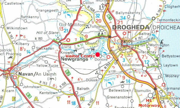 Michelin Map
Newgrange and Knowth
There is no direct public access to the passage tombs at Newgrange and Knowth by road, visitor access is only by guided tour from the Brú na Bóinne Visitor Centre on the south side of the river Boyne.
Dowth
Visitors to the mound at Dowth can drive directly to the site on the north bank of the river Boyne, located a few km from the N51 Slane to Drogheda road.
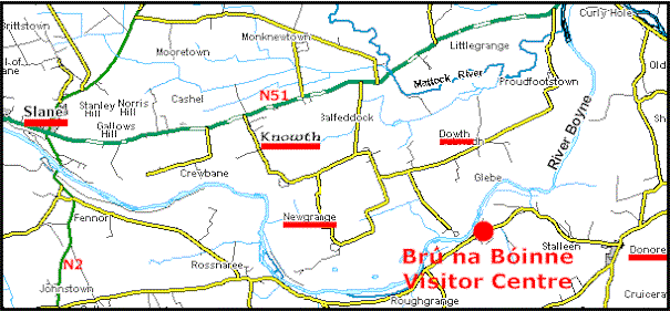 Brú na Bóinne Map
GPS Waypoints
Brú na Bóinne Centre N53° 41.720 W6° 26.807 (car park)
Newgrange (road side) N53° 41.617 W6° 28.550 (no direct visitor access)
Knowth (road side) N53° 42.124 W6° 29.460 (no direct visitor access)
Dowth Mound N53° 42.228 W6° 27.027
Slane Village N53° 42.514 W6° 32.628
Donore Village N53° 41.526 W6° 24.979 (close to the Visitor Centre)
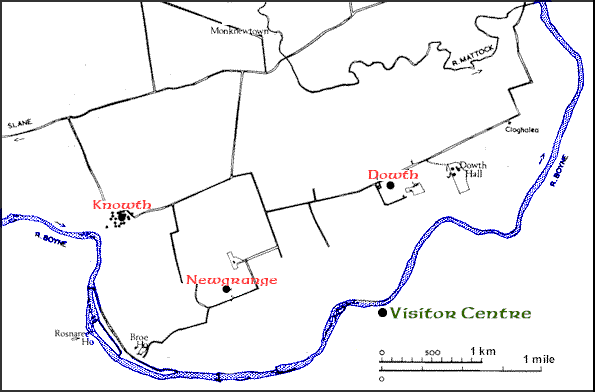 Map adapted from Newgrange - Archaeology, Art and Legend.