Discovery Maps
Detailed Maps of Irelandin 40km x 30km sections
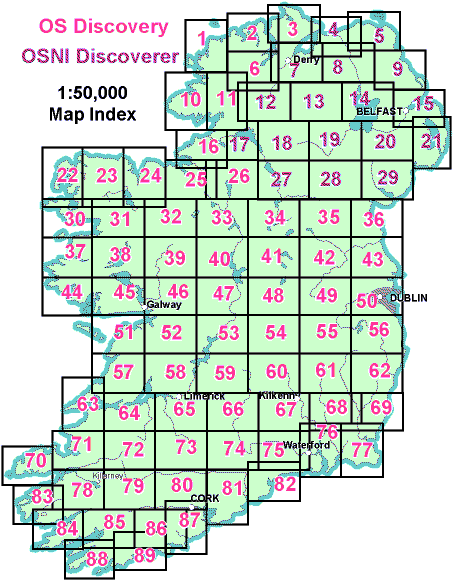
1 Donegal (Northwest)
2 Donegal (North Central)
3 Donegal (Northeast), Derry
4 Coleraine, Northern Ireland
5 Ballycastle, Northern Ireland
6 Donegal (Central), Tyrone
7 Derry, Northern Ireland
8 Ballymoney, Northern Ireland
9 Ballymena, Larne, Northern Ireland
10 Donegal (Southwest)
11 Donegal (South)
12 Strabane, Northern Ireland
13 The Sperrins, Northern Ireland
14 Lough Neagh, Northern Ireland
15 Belfast, Northern Ireland
16 Donegal, Fermanagh, Leitrim, Sligo
17 Lower Lough Erne, Northern Ireland
18 Enniskillin, Northern Ireland
19 Armagh, Northern Ireland
20 Craigavon, Northern Ireland
21 Strangford Lough, Northern Ireland
22 Mayo (Northwest)
23 Mayo (North Central)
24 Mayo (Northeast), Sligo
25 Sligo (East), Leitrim, Roscommon
26 Cavan, Fermanagh, Leitrim, Roscommon, Sligo
27 Upper Lough Erne, Northern Ireland
27A Cavan, Fermanagh, Leitrim, Monaghan
28 Monaghan, Armagh (South)
28A Cavan, Fermanagh, Monaghan, Tyrone
28B Armagh, Cavan, Monaghan, Tyrone
29 Newry & Mourne, Northern Ireland
30 Mayo (West Central)
31 Mayo (Central)
32 Mayo, Roscommon, Sligo
33 Leitrim, Longford, Roscommon, Sligo
34 Cavan, Leitrim, Longford, Meath, Monaghan
35 Cavan, Louth, Meath, Monaghan
36 Louth (Dundalk, Carlingford Lough)
37 Mayo (Southwest), Galway (Northwest)
38 Galway (North Central), Mayo (South Central)
39 Galway (Northeast), Mayo, Roscommon
40 Galway, Longford, Roscommon, Westmeath
41 Longford, Meath, Westmeath
42 Meath, Westmeath - including Loughcrew
43 Dublin, Louth, Meath - including Newgrange
44 Galway (Southwest)
45 Galway (South Central)
46 Galway (Southeast)
47 Galway, Offaly, Roscommon, Westmeath
48 Offaly, Westmeath
49 Kildare, Meath, Offaly, Westmeath
50 Dublin, Kildare, Meath, Wicklow
51 Clare (Northwest), Galway
51a Aran Islands
52 Clare, Galway
53 Clare, Galway, Offaly, Tipperary
54 Laois, Offaly, Tipperary
55 Kildare, Laois, Offaly, Wicklow
56 Wicklow, Dublin, Kildare
57 Clare (Southwest)
58 Clare, Limerick, Tipperary
59 Clare, Offaly, Tipperary
60 Kilkenny, Laois, Tipperary
61 Carlow, Kildare, Kilkenny, Laois, Wicklow
62 Carlow, Wexford, Wicklow
63 Clare, Kerry (Listowel area)
64 Clare, Kerry, Limerick
65 Clare, Limerick, Tipperary
66 Tipperary, Limerick
67 Kilkenny, Tipperary
68 Carlow, Kilkenny, Wexford
69 Wexford
70 Kerry (Dingle area)
71 Kerry (Tralee area)
72 Kerry, Cork, Limerick
73 Cork, Limerick
74 Cork, Limerick, Tipperary, Waterford
75 Kilkenny, Tipperary, Waterford (North)
76 Carlow, Kilkenny, Waterford, Wexford
77 Wexford
78 Kerry (Killorglin, Killarney) - including Killarney National Park
79 Cork, Kerry
80 Cork
81 Cork, Waterford
82 Waterford
83 Kerry (Caherciveen area)
84 Cork (Castletown Bearhaven), Kerry (Waterville, Sneem)
85 Cork (Bantry area), Kerry
86 Cork (Clonakilty)
87 Cork
88 Cork (Southwest)
89 Cork (Skibbereen area)
Boyne Valley Private Day Tour
Home
| Newgrange
| Knowth
| Dowth
| Hill of Tara
| Fourknocks
| Loughcrew
| More Places
| Labyrinths
| Local Info
| Art Works
| Articles
| Images
| Books
| Links
| Boyne Valley Tours
| Contact